

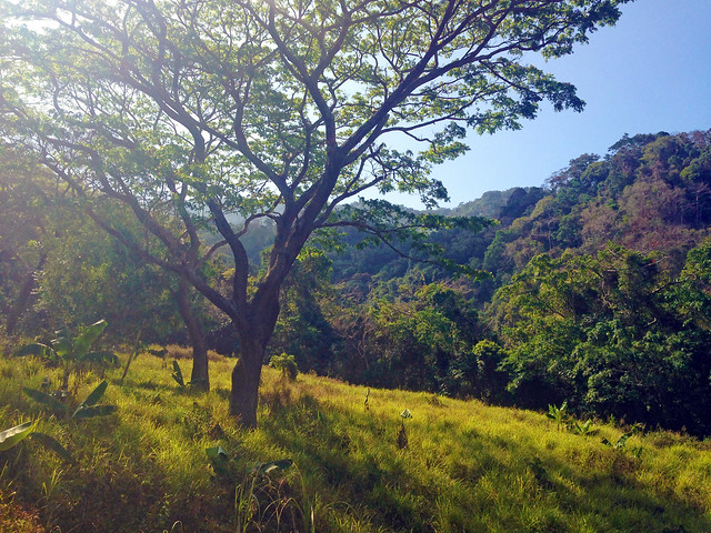


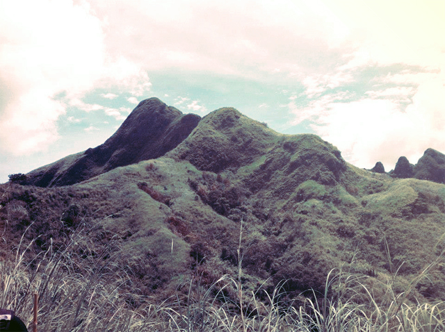
This marked the fenced military camp just along the North Peak.

[View larger version here]
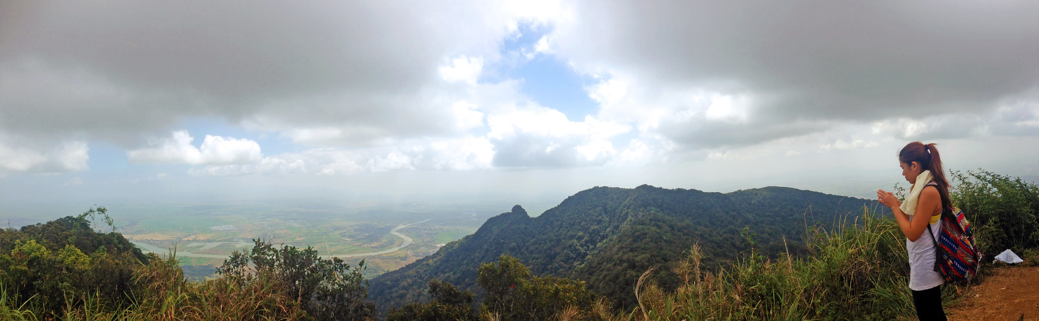
After a few photos, we had lunch here and rested a bit. We then proceeded to Haring Bato.
After a few photos, we had lunch here and rested a bit. We then proceeded to Haring Bato.


[View larger version here]
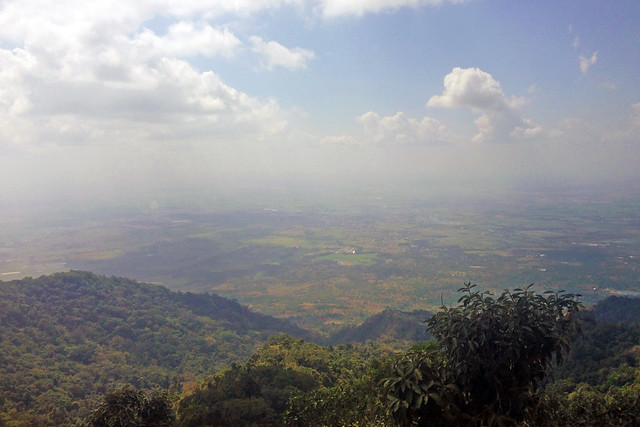
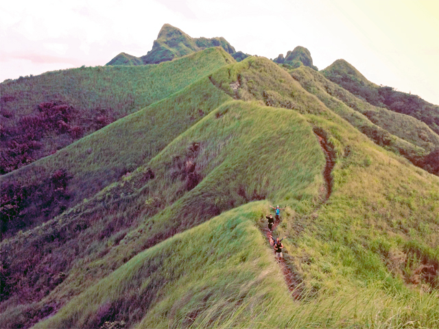
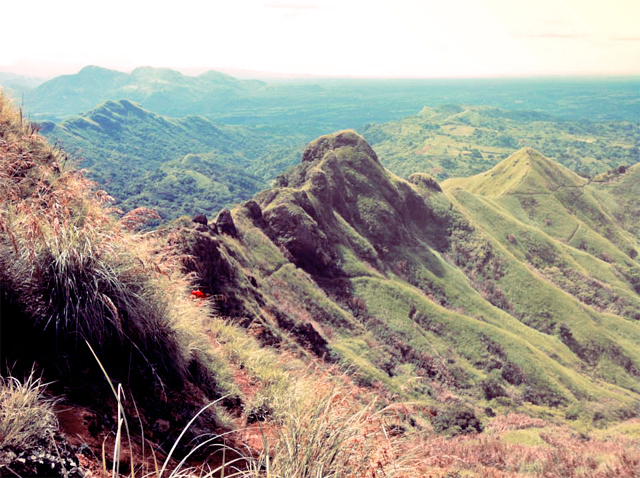
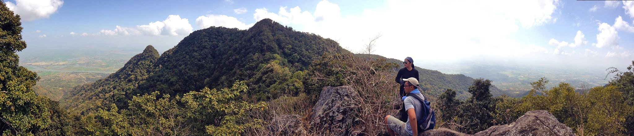
Taking a few photos by Haring Bato with a view of the South Peak and viewing deck


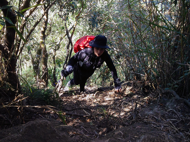
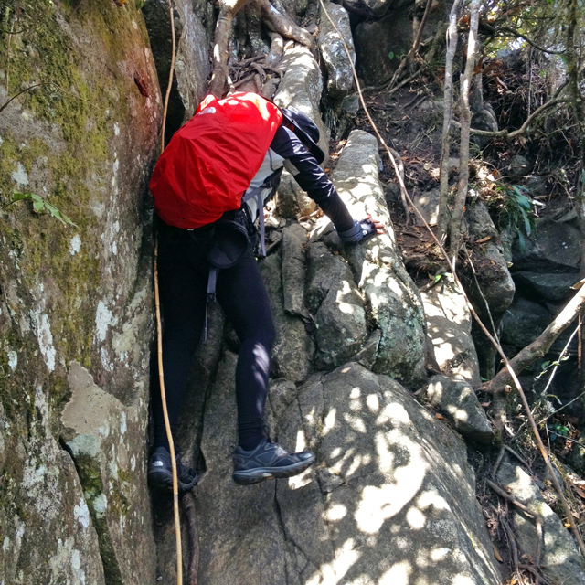
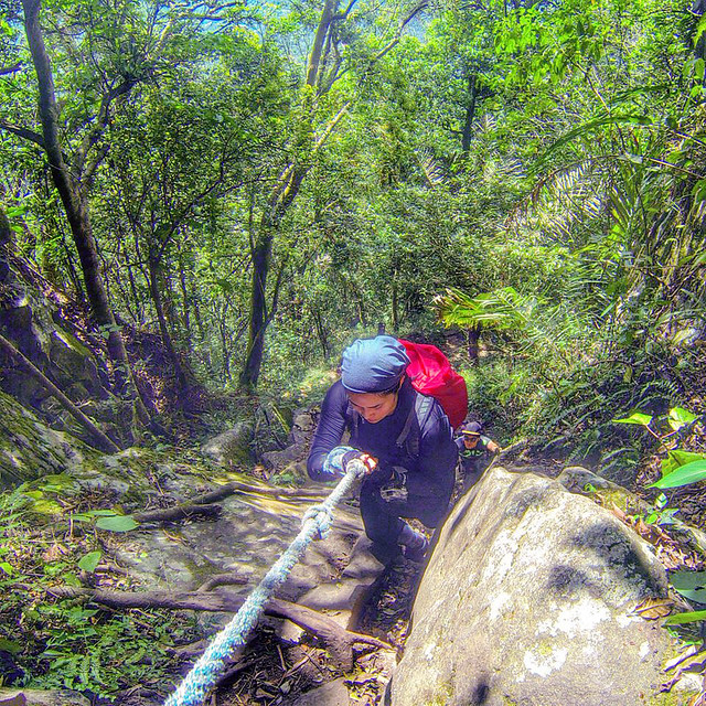
We then proceeded to descend going to South Peak. This 90° boulder was just the start of many tricky portions. We weren't expecting the technicality of the next part of the trail.


No more photos of the climb up South Peak since it was a series of deadly 85° to almost 90° slopes.

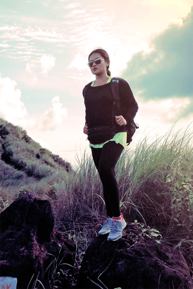
One last group photo before descending!

❧
QUICK FACTS
Mt. ARAYAT (MAGALANG-ARAYAT TRAVERSE)
(source)
Pampanga
Entry point: Brgy. Ayala, Magalang, Pampanga
Exit point: Brgy. Juan Bano, Arayat, Pampanga
LLA: 15.2067N, 120.7441E, 1,030 meters above seal level / 3,379 feet
Days required / Hours to summit: 1-2 days / 5 hours (North Peak) 8 hours (South Peak)
Specs: Major climb, Difficulty 5/9, Trail class 1-4 (10kms)
ITINERARY (source) 0400 Assembly at Victory Liner Cubao EDSA south bound. Take bus passing San Fernando, Pampanga 0500 ETD terminal 0600 Alight at SM Pampanga 0630 Take jeep bound to Magalang 0730 ETA Magalang Jollibee, breakfast, take tricycle to Brgy. Ayala (jump off), register 0830 Commence trek 1200 ETA North Peak (summit), lunch 1300 Resume trek, head to South Peak via ridge 1400 ETA Haring Bato 1500 ETA South Peak 1530 Descent 1730 ETA Bgy. San Juan Baño, Arayat 1830 Take tricycle to bayan, then jeep to SM Pampanga 1900 ETA SM Pampanga, dinner/snacks/post-climb 2200 ETA Manila
EXPENSES
Bus: Cubao to San Fernando, Pampanga - P102
Jeep: San Fernando to Magalang - P35
Tricycle: Magalang to Bgy. Ayala registration desk (jump off) - 70/trip
Tricycle: Bgy. Juan Bano to bayan - P50/trip
Jeep: to SM Pampanga - P25
Bus: San Fernando to Manila - P102
Guide: he charged us P1,100- obviously overpriced for a group of 3!
(Piece of advice for hiring guides- agree to his fee before beginning your trek and haggle!)
❧
Ayen, Jed and I were quite impulsive when we decided to head over to Mt. Arayat a few Saturdays ago. I just quickly read the itinerary and list of expenses. Jed didn't even confirm he was joining us until he showed up at the terminal. We knew this was a "major" day climb but we proceeded even if we all felt like we weren't as fit as we always were during our other climbs.
I had a hard time especially since my ankles were hurting a lot, but we managed to reach the summit on schedule. The trail consisted of a lot of boulders and roots. It resembled most parts of the climb to Tarak.
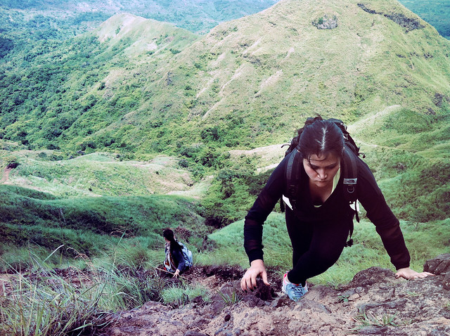
This was the most challenging mountain to date. Jed said he found it harder than our scary experience in Tarak, having our tents wrecked and not sleeping a wink since we were at the wall of the eye of the storm during Typhoon Gorio. This isn't the hardest mountain to climb but we were shocked at the "buwis-buhay" part which was, true enough, deadly, on the way to South Peak. We scrambled through 85°-90° slopes and was holding on for dear life just to advance. Ayen would signal me when to go and I would signal Jed just to make sure we weren't eating dust while going up. There were no roped segments and if you slipped, well.. goodbye. We had to make sure that each branch and root was sturdy enough for us to grab on to. We didn't take photos during this part (most of our afternoon) since "we were busy trying not to die" (Jed, LOL).
Overall, we really appreciated the challenge. We loved it more than the beautiful view since we felt like it was the real deal! The other climbs we've done are chicken sh*t in comparison. Not that any of them were easy- you have to be fit to climb, you don't climb to get fit! This is a great mountain for those with a bit of experience since it takes 8-9 hours (traverse). Hire a guide if it's your first time since the landslides are constantly changing the trails.
QUICK FACTS
Mt. ARAYAT (MAGALANG-ARAYAT TRAVERSE)
(source)
Pampanga
Entry point: Brgy. Ayala, Magalang, Pampanga
Exit point: Brgy. Juan Bano, Arayat, Pampanga
LLA: 15.2067N, 120.7441E, 1,030 meters above seal level / 3,379 feet
Days required / Hours to summit: 1-2 days / 5 hours (North Peak) 8 hours (South Peak)
Specs: Major climb, Difficulty 5/9, Trail class 1-4 (10kms)
ITINERARY (source) 0400 Assembly at Victory Liner Cubao EDSA south bound. Take bus passing San Fernando, Pampanga 0500 ETD terminal 0600 Alight at SM Pampanga 0630 Take jeep bound to Magalang 0730 ETA Magalang Jollibee, breakfast, take tricycle to Brgy. Ayala (jump off), register 0830 Commence trek 1200 ETA North Peak (summit), lunch 1300 Resume trek, head to South Peak via ridge 1400 ETA Haring Bato 1500 ETA South Peak 1530 Descent 1730 ETA Bgy. San Juan Baño, Arayat 1830 Take tricycle to bayan, then jeep to SM Pampanga 1900 ETA SM Pampanga, dinner/snacks/post-climb 2200 ETA Manila
EXPENSES
Bus: Cubao to San Fernando, Pampanga - P102
Jeep: San Fernando to Magalang - P35
Tricycle: Magalang to Bgy. Ayala registration desk (jump off) - 70/trip
Tricycle: Bgy. Juan Bano to bayan - P50/trip
Jeep: to SM Pampanga - P25
Bus: San Fernando to Manila - P102
Guide: he charged us P1,100- obviously overpriced for a group of 3!
(Piece of advice for hiring guides- agree to his fee before beginning your trek and haggle!)
❧
Ayen, Jed and I were quite impulsive when we decided to head over to Mt. Arayat a few Saturdays ago. I just quickly read the itinerary and list of expenses. Jed didn't even confirm he was joining us until he showed up at the terminal. We knew this was a "major" day climb but we proceeded even if we all felt like we weren't as fit as we always were during our other climbs.
I had a hard time especially since my ankles were hurting a lot, but we managed to reach the summit on schedule. The trail consisted of a lot of boulders and roots. It resembled most parts of the climb to Tarak.
This was the most challenging mountain to date. Jed said he found it harder than our scary experience in Tarak, having our tents wrecked and not sleeping a wink since we were at the wall of the eye of the storm during Typhoon Gorio. This isn't the hardest mountain to climb but we were shocked at the "buwis-buhay" part which was, true enough, deadly, on the way to South Peak. We scrambled through 85°-90° slopes and was holding on for dear life just to advance. Ayen would signal me when to go and I would signal Jed just to make sure we weren't eating dust while going up. There were no roped segments and if you slipped, well.. goodbye. We had to make sure that each branch and root was sturdy enough for us to grab on to. We didn't take photos during this part (most of our afternoon) since "we were busy trying not to die" (Jed, LOL).
Overall, we really appreciated the challenge. We loved it more than the beautiful view since we felt like it was the real deal! The other climbs we've done are chicken sh*t in comparison. Not that any of them were easy- you have to be fit to climb, you don't climb to get fit! This is a great mountain for those with a bit of experience since it takes 8-9 hours (traverse). Hire a guide if it's your first time since the landslides are constantly changing the trails.
❤


